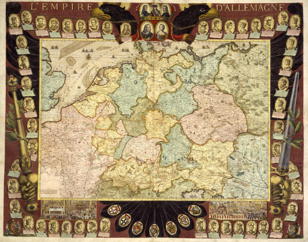
The map L’Empire d’Allemagne by Nicolas de Fer, created in 1705, depicts the Holy Roman Empire during the early 18th century. In 1705, the Holy Roman Empire was a loose and complex political structure, composed of a vast array of territories that were mostly located in central Europe. This empire was neither a centralized nation-state like modern countries nor a singular monarchy, but a collection of over 300 semi-independent entities—ranging from kingdoms, duchies, and principalities to free cities and ecclesiastical territories—united under the nominal authority of the Emperor.
Some key features of the Holy Roman Empire around 1705:
- Political Fragmentation: The Holy Roman Empire had no centralized government. Each region had its own ruler, and these rulers often acted independently of one another, with the Emperor’s power being more symbolic than executive.
- The Emperor’s Role: The Emperor was elected by the electors, a group of powerful princes. In 1705, the Emperor was Joseph I, who had ascended to the throne in 1705 after the death of his father, Leopold I. While the Emperor had some authority, real power was often in the hands of the various territorial princes.
- Territorial Complexity: The Holy Roman Empire encompassed a wide range of regions, many of which were multi-ethnic and multi-lingual. Key regions included the Austrian lands, which were ruled by the Habsburgs, the Duchy of Bavaria, the Kingdom of Prussia (which was not yet fully integrated into the Empire), and various other territories scattered throughout modern-day Germany, Austria, Czech Republic, Belgium, and parts of Italy and the Netherlands.
- Religious Divide: Religion played a central role in the Empire’s politics. The Empire had been deeply affected by the Protestant Reformation, leading to a religious divide between Catholic and Protestant territories. This division often resulted in conflict, as seen in the Thirty Years’ War (1618–1648), which had left the empire politically weakened and fragmented.
- Map Characteristics: Nicolas de Fer’s map would have included detailed borders and outlined the territories within the Holy Roman Empire, showing their division into numerous states and provinces. Such maps were not only practical for understanding the political landscape but also had a decorative element, often including elaborate cartouches, heraldic symbols, and artistic representations of the Emperor and the Empire.
In terms of the broader European context, 1705 was a period marked by the War of the Spanish Succession (1701–1714), where the Holy Roman Empire was involved as part of the anti-French coalition. The war had a significant impact on the Empire, although it did not yet directly alter its internal structure.
In sum, the Holy Roman Empire in 1705, as depicted in Nicolas de Fer’s map, was a patchwork of territories with complex internal dynamics, reflecting both the political and religious challenges of the time. The Empire would continue to exist until 1806, when it was dissolved following Napoleon’s rise to power.